Global Positioning System
Contents
Global Positioning System: Good or Bad?
Group 6
Group Members
- Antonio Ma
Introduction
The Global Positioning System (GPS) is a satellite-based navigation system made up of a network of 24 satellites placed into orbit by the U.S. Department of Defense. GPS was originally intended for military applications, but in the 1980s, the government made the system available for civilian use. GPS works in any weather conditions, anywhere in the world, 24 hours a day. There are no subscription fees or setup charges to use GPS. GPS became fully operational in 1993, it has become a widely used aid to navigation worldwide, and a useful tool for map-making, land surveying, commerce, and scientific uses. Because of GPS precise time reference, it is used in many scientific applications such as the study of earthquakes.
Statement
GPS could provide governments and civilians with beneficial uses such as, navigation, land surveying, and multiple scientific uses. However since GPS is accessed so easily and freely by anyone, and continues to grow, could the privacy and safety of people be jeopardized by this ever growing technology?
History
The first satellite navigation system was first successfully tested in 1960 by the United States Navy. Using a constellation of five satellites, it could provide a navigational fix approximately once per hour. In 1967, the U.S. Navy developed the Timation satellite which proved the ability to place accurate clocks in space, a technology that GPS relies upon. In the 1970s, the ground-based Omega Navigation System, based on signal phase comparison, became the first worldwide radio navigation system. In 1978 the first Global Positioning System satellite was launched eventually leading to a full constellation of 24 satellites in 1994.
How It Works / Technology
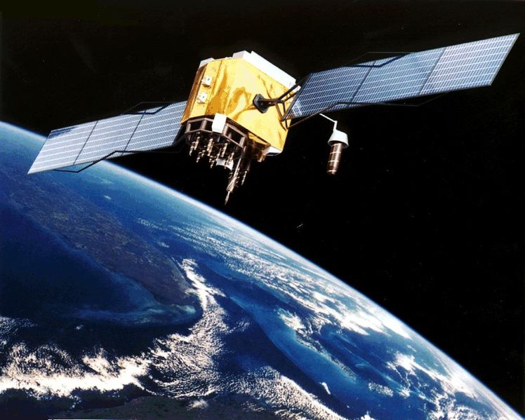
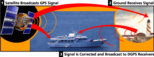
GPS satellites circle the earth twice a day in a very precise orbit and transmit signal information to earth. GPS receivers take this information and use triangulation to calculate the user's exact location. Users can also get better accuracy with Differential GPS(DGPS), which corrects GPS signals to within an average of three to five meters. The U.S. Coast Guard operates the most common DGPS correction service. Essentially, the GPS receiver compares the time a signal was transmitted by a satellite with the time it was received. The time difference tells the GPS receiver how far away the satellite is. Now, with distance measurements from a few more satellites, the receiver can determine the user's position and display it on the unit's electronic map. A GPS receiver must be locked on to the signal of at least three satellites to calculate a 2D position (latitude and longitude) and track movement. With four or more satellites in view, the receiver can determine the user's 3D position (latitude, longitude and altitude). Once the user's position has been determined, the GPS unit can calculate other information, such as speed, bearing, track, trip distance, distance to destination, sunrise and sunset time and more.
- Each satellite is built to last about 10 years. Replacements are constantly being built and launched into orbit.
- A GPS satellite weighs approximately 2,000 pounds and is about 17 feet across with the solar panels extended.
- Transmitter power is only 50 watts or less.
- The following link gives more information on how GPS works
Pros
Vehicle and Traveling Purposes:
If your vehicle had a GPS system and you were traveling or lost, GPS can provide you with directions and various other, useful information such as how far you have traveled, how long you have been traveling for, current speed, average speed, and most importantly estimated time of arrival. A vehicle with GPS could also provide authorities with your location in case of an emergency(Onstar). Also in the situation where your vehicle is stolen, GPS could be used to track and retrieve your Vehicle.
Construction and Surveying Purposes:
Mapping, construction, and surveying companies use GPS extensively. During construction of the tunnel under the English Channel, British and French crews started digging from opposite ends: one from Dover, England, and one from Calais, France. They relied on GPS receivers outside the tunnel to check their positions along the way and to make sure they met exactly in the middle. Otherwise, the tunnel might have been crooked. GPS allows mine operators to navigate mining equipment safely, even when visibility is obscured. GPS is also used during the constructions of buildings to detect structural problems.
Military Purposes:
GPS was used during multiple military operations. During operation Desert Storm U.S. forces was able to maneuver in the wide featureless expanses of sand. With GPS the soldiers were able to go places and maneuver in sandstorms or at night when even the Iraqi troops who lived there couldn’t. More than 1,000 portable commercial receivers were initially purchased for their use. They were carried by soldiers on the ground and were attached to vehicles, helicopters, and aircraft instrument panels. GPS receivers were used in several aircraft, including F-16 fighters, KC-135 aerial tankers, and B-52 bombers. Navy ships used them for rendezvous, minesweeping, and aircraft operations.
Emergency Situations:
GPS is helping to save lives and property across the nation. In 2002, it enabled rescuers to drill a shaft to free trapped miners in Somerset PA. Many police, fire, and emergency medical-service units use GPS receivers to determine the police car, fire truck, or ambulance nearest to an emergency, enabling the quickest possible response in life-or-death situations. GPS-equipped aircraft can quickly plot the perimeter of a forest fire so fire supervisors can produce updated maps in the field and send firefighters safely to key hot spots. Scientist can also use GPS to detect the movement of tectonic plates, and predict earthquakes, allowing time to prepare, which could save countless lives.
Cons
Invasion of Privacy:
One of the major concerns with GPS is the easy availability, with anyone being able to access this technology, anyone is able to track anyone. Recently Japan has produced low-cost GPS systems both retailing for under 50$, they can be placed inside a mobile phone or built into a shoe. Parents use these new products and allows them to track their child, however in many situations this has developed an "unhealthy and destructive" relationship with their child.
Simon Davis, director of campaign group Privacy International, feared parents using GPS would find it both ineffective and dangerous.
"What this can result in - and we've seen this through visual surveillance technology and bugs that can be put into children's bedrooms - is parents becoming obsessed, to the point of having an unhealthy and destructive relationship with their children," he said.
Predators using GPS:
The trend for using GPS for tracking children began in Japan, with school backpacks and blazers being fitted with transmitters. These were hooked up to a monitoring headquarters at a security firm. However, people with sinister intent could find ways to use these GPS systems and also track and endanger children.
GPS Interference:
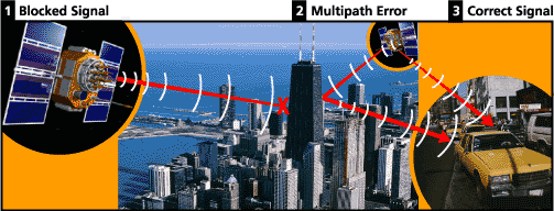
Certain factors can degrade the GPS signal and affect accuracy. Tall buildings could block GPS signals, also the signal could also be reflected with certain objects causing multipath errors which delays the signals.
Conclusion
Like with any technology, it depends who is using it and how they use it. Parents who do use the technology to track their children may be invading their privacy, however in a situation where sometime does happen, it will give them comfort in knowing that there is a way to track them down. A similar situation that has been highly effective is used by the police. When people call 911 emergency the system is designed to identify where the caller is, enabling the police to act quick and effectively. Even though people say this technology has invaded privacy, I believe that any technology could be bad if used in the wrong hands. This technology has saved countless lives, helped with emergency's, made traveling easier, made buildings safer, and made life easier for many people. With all these benefits I believe that the Pros outweigh the Cons, and that the GPS system should be accepted and allowed to continually grow within our society.
References
1) Steven, Storm. "Charting a Course Toward Global Navigation," http://www.aero.org/publications/crosslink/summer2002/01.html. (accessed April 17 2009).
2) Wikipedia "GPS." http://en.wikipedia.org/wiki/GPS (accessed Apr 17, 2009).
3) BBC News "Guide to military strength." http://news.bbc.co.uk/2/hi/americas/1557140.stm#gps (accessed Apr 17, 2009).
4) "What is GPS?" http://scign.jpl.nasa.gov/learn/gps1.htm (accessed Apr 17, 2009).
5) "How is GPS used" http://www.trimble.com/gps/index.shtml(accessed Apr 17, 2009).
6) Beyond Discovery "THE HISTORY OF GPS" http://www.beyonddiscovery.org/content/view.article.asp?a=458 (accessed Apr 17, 2009).
7) Beyond Discovery "A tool to discover nature" http://www.beyonddiscovery.org/content/view.article.asp?a=458 (accessed Apr 17, 2009).
8) Beyond Discovery "GPS and its future uses" http://www.beyonddiscovery.org/content/view.page.asp?I=468 (accessed Apr 17, 2009).
9) BBC News "Tracking Children With GPS." http://locationtechnology.blogspot.com/2006/04/tracking-children-with-gps-good-or-bad.html (accessed Apr 17, 2009).
10) "Is GPS tracking Good or Bad?" http://www.thewebtechreviews.com/2009/03/05/gps-tracking-system-good-or-bad/ (accessed Apr 17, 2009).
11) Everyday Mysteries "What is GPS?" http://www.loc.gov/rr/scitech/mysteries/global.html (accessed Apr 17, 2009).
12) "The History of GPS" http://www.streetdirectory.com/travel_guide/117588/gps_vehicle_tracking/the_history_of_gps.html (accessed Apr 17, 2009).
13) AeroSpace "What is GPS?" http://www.aero.org/education/primers/gps/whatisgps.html (accessed Apr 17, 2009).
14) AeroSapce "Uses for GPS." http://www.aero.org/education/primers/gps/uses.html (accessed Apr 17, 2009).
15) "What are GPS used for?" http://www.novatel.com/gps/gps_systems.html (accessed Apr 17, 2009).
16) CBC NEWS "GPS surveillance"http://www.cbc.ca/news/background/tech/gps.html (accessed Apr 17, 2009).
17) "What is GPS?" http://www.webopedia.com/TERM/G/GPS.html (accessed Apr 17, 2009).
18) Simon , Davis. "Communication Surveillance" http://www.privacyinternational.org/index (accessed Apr 17, 2009).
19) Simon, Davis. "Satellite Surveillance" http://www.privacyinternational.org/article.shtml?cmd[347]=x-347-559095 (accessed Apr 17, 2009).
20) “Overview of GPS Interference Issues” http://www.loran.org/ILAArchive/LanghorneBondPapers/07OverviewOfGPSInterferenceIssues.pdf(accessed Apr 17, 2009)
21) YouTube “How GPS works” http://www.youtube.com/watch?v=wi_3XwkA8cQ (access Apr 17, 2009)
22) “Uses of GPS in the Field by Scientists” http://www.mapwatch.com/gps/gps-science-field-work.shtml (access Apr 17, 2009)
23)"GPS Pros and Cons" http://www.gpspassion.com/en/hardware/GPSprosandcons.htm (Retrieved on Apr 17, 2009)


