I Spy You on Google Maps
Contents
Project Title: I Spy You on Google Maps
Group Members

Clarissa Fan
Nisha Valckx
Brian Chow
Introduction
Google Maps: What is it?
Want to visit a friend but have no idea about the neighbourhood? Passing through a town and too cheap to buy a map? Well, what do you know...Google has it!
Using Google Maps, a free (yes, free!) online mapping application, you can see just about anything, anywhere. Users don’t even need a Google account to use most of the service. Google Maps provides locations of cities, businesses, local attractions, houses, and more. Users can navigate the maps through use of the zoom-in feature and panning (dragging the mouse in any direction on the map). The most interesting and controversial features about Google Maps are the real-life images of streets which can be found in Google Street View and Earth. Street View takes photos while Google Earth provides satellite aerial photos.
Google Maps can also generate driving directions from location to location, even providing trip time, distance, and turn-by-turn instructions. However, this feature is currently only available in the United States of America, Canada, and other select countries. A special feature for users with registered Google accounts is the ability to edit the location of position markers for businesses and other locations, as well as their descriptions. It’s not a free-for-all though, as changes of 200m or more require the approval of a moderator first.
Statement of Position
Photos of streets and the surrounding environment on Google Maps viewed through Street View and Google Earth are unique and innovative technologies. The visuals are excellent for those who have problems finding their destinations from a 2D regular map. However, both Street View and Google Earth raise concerns about its potential negative impacts on national and personal security, and privacy. These two features of Google Street Map are new and Google has made improvements after initial blunders. However, the improvements are insufficient to preserve security and privacy. The issue of the technology behind Street View and Google Earth will become increasingly important as more companies emerge with improved detailed imaging. Concerns regarding security and privacy can be addressed as early as possible to meet the future obstacles caused by newer advanced street imaging technologies.
The Technology
Five Different View Modes
Google Maps relies heavily on the synchronised use of JavaScript and XMLHttpRequest, collectively known as ‘Ajax’. It has five different view modes that are used widely:
1. Map: Map view provides the usual street map of a region, the same as would normally be found in a real, hand-held map.
2. Traffic: Traffic view will highlight roads with typically heavy traffic congestion.
3. Terrain: Terrain view adds to Map view by displaying the high relief topography of an area.
4. Satellite: used by Google Earth
5. Street: also known as Street View
Another feature of Google Maps is Google Maps API, which allows users to freely display Google Maps on their own websites, complete with their own personalized data points. Google Maps API can be used commercially (eg. By real estate agents), and while it currently does not contain any ads, Google has reserved the right to do so if they see fit in the future.
Google Earth and Street View both offer photos of real-life, thus creating security and privacy issues.
Street View
Street View offers ground level, 360 degree visualisations of public roads and streets. This is done by mounting cameras on top of a car and then driving through streets while capturing images. This feature was only introduced in May 2007 and is currently only available in the USA. This has been a source of much recent controversy concerning the general public, whose images are frequently captured and indiscriminately posted online.
Google Earth
Google Earth is derived from Google Maps and uses Satellite View to provide photos. Satellite view provides detailed, high-resolution satellite imagery as well as photographs taken from airplanes. This bird’s eye view of the world is provided for urban areas in numerous countries. While the age of the photographs is questionable (some rumoured to be dating as far back as 2001, and photos do not include the date and time they were taken), some of these images have been removed due to security concerns (eg. Government installations in the USA)
Security Risks
Google Maps can take photos containing sensitive information, such as military bases and nuclear sites. These photos can potentially be used to the advantage for terrorists and others intending malicious harm. Below are two incidents which demonstrate the potential security risk.
Street View Example
According to Los Angeles Times, the U.S. Pentagon banned Google's digital-mapping vehicles from all US military security premises after Google Maps posted detailed photographs of Fort Sam Houston in San Antonio during early March The U.S. Northern Command's spokesperson, Gary Ross, stated that the photographs were sensitive information that posed a threat to national security. He stated that ' "Street View provides clear imagery of control points, barriers, headquarters and security facilities that pose a risk to our force-protection efforts" '. Pentagon requested for the images to be taken down. Google complied with the request and acknowledged its error in taking sensitive photos of the base. Google is working with the U.S. Defense Department to prevent further postings of sensitive images that can infringe national security.
Los Angeles Times revealed that a base official had granted access to the Google digital-mapping vehicles twice. The official believed an online map on the popular Google Street View would aid in guiding visitors. Above all, he approved access on the assurance that Google would avoid videotaping or photographing the militarily important base. Quite clearly, Google broke the promise. In addition, Google's spokesperson, Larry Yu, stated that Google's driver at that incident violated Google's strict policy, which forbids any attempts onto military premises and private property.
This example points to several serious issues associated with Google Street View. First, Google's photos are detailed enough to cause alarm within the U.S. Defense Department. One may argue that governments, particularly the U.S. one, have become extremely sensitive since terrorist attacks on 9/11, however it should also be noted that the base official on Fort Sam Houston had granted permission of access to Google twice. Second, on premises where Google had to acquire permission of the owners to enter their fenced property to take photos, it is difficult to make the photographers in the Google digital-mapping vehicle accountable for their actions. Though Google has a "strict policy" to prevent infringement on security and privacy, the policy was not followed in the case of Fort Sam Houston. This incident may be the odd occurrence, but videos and photographs taken by Google discussed later prove the opposite. To remedy the problem, the owner or someone else can accompany the Google photographers. However, the physical surveillance of Google digital-mapping vehicles will surely be a nuisance for the owners. Most owners will probably refuse access to their property grounds to Google photographers all together.
Google Earth Example
The Australian Nuclear Science and Technology Organization (ANSTO), the operator in charge of Australia's nuclear reactor at Lucas Heights in Sydney, demanded that Google review and censor Google Earth images of the reactor. Details including the center of the reactor attached to other buildings by large white pipes, cars, trees and perimeter fences can be found in the aerial view of the reactor.
Intelligent Risks CEO Neil Fergus stated that this is one of many serious security risks Google Earth creates. He described the possibility of the aerial image of possessing "real tactical and logistical interest to a terrorist group". The question about censoring critical locations is determining which sites are of security importance. A censoring of this Australian nuclear reactor would be a precedent on Google Earth, yet the rooftop of the U.S. Whitehouse and several other Washington buildings are coloured in Google Earth.
(Image from http://www.abc.net.au/news/indepth/featureitems/s1432602.htm)
Privacy Intrusions
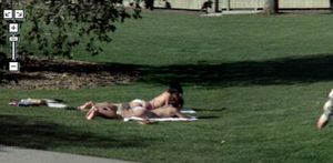
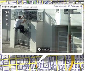
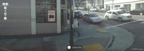
The use of Street View and Google Earth on Google Maps is also a concern for people's privacy. People's faces have been caught clearly on the photos during awkward situations. The fact that the person can be identified on the photos also associates a location with the person which the individual might not be happy to have on the Internet. The following contains photos found on Google Maps which usually will not be put up for the public to see by the individuals in the photos.
Personal Snapshots
1. Even though the two girls above are sunbathing in public, does this infer that Google Street View is allowed to put photos of them on the Internet? People would not give usually give permissions to Google to put up personal photos of themselves.
(Image from http://mashable.com/2007/05/31/top-15-google-street-view-sightings/)
2. In San Francisco, Street View showed a man attempting to climb a fenced door. Immediately, the man's intentions are questioned and most viewers would suspect that he was caught in the act of a criminal break-in. Though one may argue that Google Maps can catch criminals, it is not the purpose of Google Maps to monitor the public. Photos from Google Street View and Earth are intended to help people in finding their way to their destinations.
(Image from http://www.poormojo.org/pmjadaily/archives/015997.php)
3. A man was photographed outside a strip club with his face clearly visible. Not a lot of people would be happy to learn that a photo of them standing in front a strip club is available for the public to view on the Internet. Again, even though the person might be in wrong, does not mean that Google has the right to put photos of these people on the Internet for the public to see.
(Image from http://mashable.com/2007/05/31/top-15-google-street-view-sightings/)
Removing Photos off Google Maps
On the right is a Google Street View photo of a street a few blocks away from Electronic Frontier Foundation (EFF)'s headquarters (Image from http://blog.wired.com/27bstroke6/2007/06/eff_privacy_adv.html).
EFF is an international nonprofit legal and advocacy organization with the aim to protect civil liberty issues related to technology. The person in the image is EFF's staff attorney, Kevin Bankston. Bankston argued that "Street View is legal, but irresponsible" (http://en.wikipedia.org/wiki/Electronic_Frontier_Foundation). Google replied to his request to take down the image that a valid photo's ID needed to be send to Google:
"Attach a clear, readable copy of a valid photo ID (e.g. driver's license, national ID card, etc). If you are requesting removal of an image of a location, attach a copy of a document demonstrating your association with that location ( e.g. business card or letterhead)"
(http://blog.wired.com/27bstroke6/2007/06/want_off_street.html).
Rather than giving out further personal information to Google, Bankston preferred to leave the image of himself up instead of sending an important piece of ID such as a driver's license. Fortunately, Google changed the policy and requested only name and location of the image for anyone caught in a Google Street View photo:
"In order to confirm that you are the person shown, and that you are
formally requesting removal of your image from the Maps service, please complete the following and reply to this email. We will temporarily remove the Street View image pending receipt of your response to this email. If we have not received the response within 5 days, then we will restore the panorama back to Street View.
- Your name:
- The location of the image in our service
By responding, you are representing and confirming that you are the person depicted (or parent/guardian) and that you seek removal of the image. Google will only use the information you send in this email for purposes of processing and responding to your request for the image to be removed.
Regards,
The Google Team
(http://blog.wired.com/27bstroke6/2007/06/want_off_street.html)"
In present society where the news media can be sued for neglecting to ask permission to publish photos of people, most individuals would prefer not to have photos of themselves on the Internet, available for anyone to see on Street View. Google has corrected its previous unreasonable demand for more personal information in in exchange for the removal of images of individuals on Street View. Instead of asking for more sensitive personal information with a photo ID such as a driver's license, Google simply needs a name and location of the photo to remove the image. However, people would have to be initially aware of their photos on Street View and their faces are still left recognizable in the images. Google does not automatically discard photos of streets with people's faces visible in them. It is up to the unlucky individuals caught in one of Google Maps' photos to search and request for the removal of the photos. To show concern for the privacy of people, it is best that Google make a policy that no photos of individuals should be taken and placed on Street View or as Bankston suggested, implement a facial obfuscation technology to blur faces.
Conclusion
The discussion of the issue concludes that there should be tighter regulations imposed on Google with regards to the content of the photos it can take in the public sphere. As an alternative, Google might want to consider enforcing stricter self-regulatory policies to alleviate the public's fear of security and privacy intrusions. For instance, removing and filtering photos with people in them from Google Street View and Earth, or blurring people's faces in those photos. Google Street View and Earth are innovative technologies, and the public should be able to enjoy its advantages. Since the use of Google Maps increased dramatically in the recent years, it is suggested that Google enforce the regulations to protect the security and privacy of the people in the cities that Google Street View and Earth operate in. Therefore, Google Street View and Earth will be welcomed into all corners of the world.
References
Nisha Valckx
Clarissa Fan
Bryan Chow


