T12 GROUP 1
Contents
GPS: Global Positioning System
Group Name
Team Awesome :)
Group Members
Audrie Sham | Chao Liang | Tian Lan | Jamil Bhanji | Atif Hirjee
What is Global Positioning System
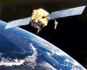
GPS is a worldwide, space based, Global Navigation Satellite System (GNSS) that provides navigation as well as information about position (longitude, latitude and altitude), and time and velocity of an object. It was originally designed specifically for use in the US military where it was, and still is today, funded and controlled by the US Department of Defence (DOD). It was not until 1983 that President Ronald Reagan decided that GPS should be accessible by all civilians as a common good that can be purchased from local retailers. The GPS is a constellation of 24 satellites orbiting the earth that can pinpoint the geographic location of anyone with a ground receiver. This location is accurate from about 100 to 10 meters, depending on the equipment used, and about 1 meter with special military approved equipment. Global Positioning System works anywhere in the world, in any weather, 24 hours a day without any fees or set up charges.
The History of GPS
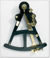
Early advancements in navigation were the compass and sextant. As the compass's needle always points north, the instrument told seamen the direction they were traveling. The sextant measures angles of stars, the moon, and the sun above the horizon. However, the first sextants were only able to measure latitude and not longitude. In 1761, the chronometer was invented and was used to measure longitude. Travelers used both the sextant and chronometer to calculate latitude and longitude.
The first radio-based navigation systems were established in the early 1900s and were used in World War II. However, a choice needed to be made between an accurate high-frequency system which only covered a small area, or a low-frequency system that covered a large area, but proved inaccurate.
The first discovery of using a satellite for navigation was in 1957, when the Russian satellite Sputnik was launched into space. Researchers were able to figure out the orbit of the satellite by discovering it's radio signal escalated as it approached and diminished as it left. Radio signals from the satellite were crucial in determining an object's position on Earth, as was the revelation of tracking a satellite's location from the ground.
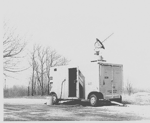
"Transit" was the first satellite navigation system. It was successfully tested in 1960 by the U.S. Navy. The "Transit" system was able to tell testers the information about navigational fix once every hour by using a constellation of five satellites. The testers used the Doppler shift of the radio signals and navy submarines were able to pick up nuclear submarines' signals within fifteen minutes.
After "Transit", the United States Navy continued to make progress on their satellites technology. The goal was to allow people to receive accurate times in different spaces by using satellite systems. The U.S. made numerous efforts on their satellites technology in order to reach this goal. Finally, this pursuit was successful as the Timation satellite system was developed in 1964 and launched in 1967.
In the 1970s, a radio navigation system was produced based on the technology of signal phase comparison. This ground-based radio navigation system was called the Omega Navigation System. The development of this technology is closely related to today's GPS because the design of the first Global Positioning System was based on this ground-based radio navigation system.
How GPS Works
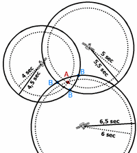
The basic idea behind GPS is the distance between the satellites and the receiver. At least 3 of the 24 satellites must know the distance in order to find the position of the receiver. Both the satellite and the receiver produce a duplicate radio signal at exactly the same time. The signals travel at the speed of light, or 186 000 miles per second. It takes a few hundredths of a second for the signal to travel from the satellite to the receiver, and the differences and the speed of the signal is used to find the distance between the two in the equation:
SPEED X TIME = DISTANCE
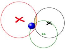
If it takes 0.09 seconds for the signal to go from the satellite to the receiver, the distance would be 186 000 miles per second X 0.09 seconds = 16 740 miles. Therefore the receiver must be in a radius of 16 740 miles. If it takes the second signal 0.08 seconds to reach the receiver from a second satellite then the receiver is located somewhere on a radius of 14 880 miles, and where the 2 spheres intersect. If the third signal takes 0.07 seconds to reach the receiver then the GPS must be located somewhere on a radius of 13 020 miles, and where the three satellites intersect. The satellite signals contain more data then the GPS receiver uses to calculate distance. It contains data the receiver uses to make adjustments to get an accurate position. As well, atmospheric data is sent to the receiver to calculate delays in the time it takes the signal to reach the receiver. These delays are caused by the ionosphere and the troposphere. The information sent from the satellite usually works with software in the receiver to display the location of the GPS user in the form of a map.
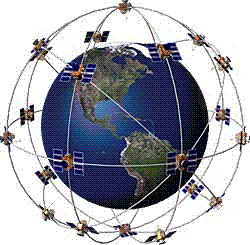
To find the various pieces of information, GPS uses 24 Earth-orbiting satellites that continuously send signals to the receiver. These satellites, at an altitude of about 20,000 Km, have circular orbits of only 12 hours, which means it can circle Earth twice a day. The GPS Operation Constellation consists of six orbital planes (four satellites in each) that are spaced 60 degrees apart and inclined at about fifty-five degrees with respect to the equatorial plane. With these configurations, at any point on Earth, the receiver should be able to spot between five and eight satellites.
GPS needs to receive signals from four different satellites which are then used to identify the locations of each of the satellites and the distance from the satellites to the GPS. This information is used in a mathematical principle called ‘trilateration’ that can calculate precise coordinates. Trilateration applies the use of intersecting spheres to pinpoint a unique position where all the spheres connect. Each satellite is also equipped with an atomic clock that synchronizes to each receiver to calculate precise timing of the GPS.
Different Types of GPS Devices
Today, GPS can be found in various places around the world with numerous purposes as it is such a useful tool. For instance, it can be used in cars, boats, planes to locate, navigate and to give estimated times of arrival. It is used with disaster relief teams in order to help them find survivors and also been used with those emergency services for life-saving missions. Now, farmers, geologists and many other occupations depend on Global Positioning System to perform their tasks more efficiently, safely and accurately.
Functions of GPS Devices
There are all kinds of GPS Devices which have been used in people's daily life now. The choices on them is depending on the frequency and the purpose of using them. The three most popular GPS Device functions are:
1.GPS Mapping: Useful for finding the location of any address in the world. In order to find the destination, people only need to type the address of the location. This technology will allow people to find the location within few seconds,it can also give you detailed directions and the estimated length of the trip.
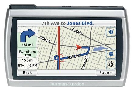
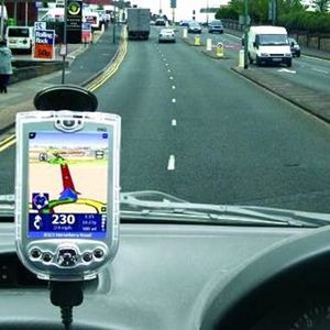
2.GPS Navigational Unit: Usually mounted in a vehicle and can walk you through a trip telling you exactly when to turn and the distance needed to be traveled at each portion of the trip. Can also find various locations that you may be unfamiliar with.
3.GPS Tracking: Tracks a person or thing. Can be used to keep track of possessions such as cars. For instance, many parents mounted this type of GPS device in their teenager drivers' cars to make sure their safty. Also, people can use this device to protect their valuables from being stolen.
Types of GPS Units
1.Basic Units: The receiver with a small set of functions. They report the desired location with latitude and longitude and usually have a base map of a certain region. These units are for low-budget individuals who use them for simple navigation.
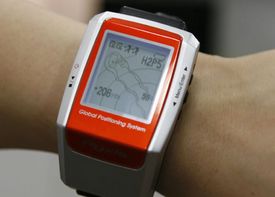
2.Sport/Training Units: Generally worn by training athletes on their wrists. The units have features like heart rate and calorie count monitors, as well as technology that lets the user set their workout goals.
3.Portable Units: Used in cars or by pedestrians. Lower end models have small screens and limited memory capacity, which carry maps of a specific region. High end models have large screens and more memory capacity. They also have features such as satellite radio and Bluetooth capabilities.4.Car GPS units: Two types of car GPS units. The first is the portable unit, described above. These units are equipped with certain accessories for use exclusively in automobiles such as suction cups to attach to the windshield. The second is the in-dash unit, which are available as an option in high-end vehicles. These units have features that bode well with other car electronics and are generally more expensive than portable units.
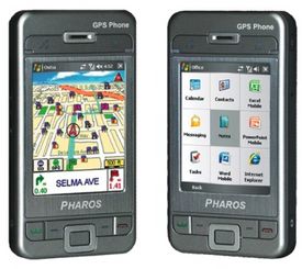
5.Wireless Technology: GPS technology is becoming more and more abundant wireless devices such as PDAs (Personal Data Assistant), mobile phones and laptops. GPS on a PDA or mobile phone is useful as the handheld device is capable of many other functions. GPS available on laptops take up memory and hard disk capacity, but are somewhat cheaper than other units.
The Issues of GPS
The issues that arise with this technology are the errors in the accuracy of the results dealing with:
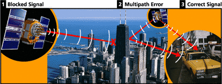
Multipath signal issues: It occur when the signal moving towards the receiver bounces off multiple items, such as tall buildings and canyon walls, before being sent to the GPS. This makes the distance and also the time calculated inaccurate.
Atomosphere delays: It happen in both the ionosphere (50-500Km above sea level) and the troposphere (8-13Km above sea level).
- The ionized air in the ionosphere delays the speed of the microwave signals that are sent to the receiver.
- In the troposphere, when there is more humidity than usual, it can also amount to a delay in receiving the signal.
Visibility of satellites: Buildings, terrain, electronic interference and sometimes even dense foliage are all possible conditions in which the signal may not reach the receiver. GPS units do not work well indoors, underwater or underground. Due to these conditions,the GPS may receive position errors or sometimes no position readings at all.
Sources
Tian Lan's sources
http://en.wikipedia.org/wiki/Global_Positioning_System
http://ezinearticles.com/?Types-Of-GPS-Devices&id=406460
http://www.nps.gov/gis/gps/history.html
http://ezinearticles.com/?Types-Of-GPS-Devices&id=406460
http://www.associatedcontent.com/article/443982/types_of_portable_gps_devices.html
http://ezinearticles.com/?What-Is-GPS-and-How-Can-It-Be-Used?&id=263052
http://www.gps-practice-and-fun.com/
http://gpstracklog.typepad.com/gps_tracklog/2006/03/can_my_gps_be_u.html
Chao Liang's sources
http://www.maps-gps-info.com/hw-gp-wrks.html
http://www.trimble.com/gps/index.shtml
http://www.howstuffworks.com/gps.htm
http://scign.jpl.nasa.gov/learn/gps1.htm
http://www8.garmin.com/aboutGPS/
http://www.aero.org/education/primers/gps/uses.html
http://www.colorado.edu/geography/gcraft/notes/gps/gps_f.html
http://www.nps.gov/gis/gps/history.html
Jamil Bhanji's Sources
http://searchmobilecomputing.techtarget.com/sDefinition/0,,sid40_gci213986,00.html
http://www8.garmin.com/aboutGPS/
http://support.radioshack.com/support_tutorials/gps/gps_main.htm
http://support.radioshack.com/support_tutorials/gps/gps_works.htm
http://www8.garmin.com/aboutGPS/
http://support.radioshack.com/support_tutorials/gps/gps_works.htm
http://www.kowoma.de/en/gps/positioning.htm
http://www.spaceandtech.com/spacedata/constellations/navstar-gps_consum.shtml
http://adventure.howstuffworks.com/gps.htm/printable
http://www.nasm.si.edu/gps/work.html
Atif Hirjee's Sources
http://support.radioshack.com/support_tutorials/gps/gps_hist.htm
http://support.radioshack.com/support_tutorials/gps/gps_tmline.htm
http://www.thegpsguide.com/gps_systems.html
http://www.gps-practice-and-fun.com/gps-receivers.html
http://www.gisdevelopment.net/history/links/gps.htm
http://www.solarnavigator.net/compass.htm
http://www.archives.gov.on.ca/english/exhibits/thompson/bigs/big_02a_sextant.htm
http://www.itechnews.net/2007/08/16/pharos-gps-phone-600/
http://www.navigadget.com/index.php/2007/07/30/gps-watch-for-golfers-pyxis-rgps-3000
