T16 Group4
GOOGLE MAPS

Formal Proposal
Team Members: Arman, Stacey and Sarah
Technology: Google Maps
Issues that will be addressed:
Memory – Memory issue on Google map because of the amount needed for all the streets, towns, cities that need to be included.
Speed – How long it takes to download from entering the address to the starting page then to the page you want to download, this can be an issue because there is a lot of images to download.
Graphic – The quality of the images of the maps provided and the lengthy process of processing these images from space to be the most accurate they can be.
Keeping it Updated – This is a critical issue, Google maps must be kept updated because many users use this as a primary resource instead of buying a map. Therefore, if this is not kept up to date they will risk becoming depleted and many complaints.
These are the issues we will be discussing throughout the final report and possible solutions to these problems.
Breif History of Google Maps
Google Maps is a world wide website that allows any consumer to log on and type in the directions they would like from one destination to another. There are visuals and directs in words to suit any consumers needs. The issues with this website are speed of download which could experience websnarl, needs enough memory to hold all the data, graphics need to be quality and a crucial issue is being up-to-date. Keeping up to date is critical because some consumers depend on Google Maps to find their way therefore, if it’s not updated frequently then will suffer from complaints

Memory
GFS:
Google File system grew out of the earlier Google effort, "Big Files", developed by Larry Page and Sergey Brin in the early days of Google. Files are devided into chunks of 64 megabytes, which are extremely rarely overwritten, or shrunk. GFS is optimised to run on Google's computing clusters, in which the nodes consist of cheap, "commodity" computers, which means there can be a high risk of failure and data loss.
There are two types of nodes:
1) A large number of chunkservers:
Chunkservers are used to store the data in chunks of 64 megabytes. Similar to clusters or sectors in regular file systems. Each chunk is assigned a unique 64-bit label. Similar to how a ram operates.

2) A master node:
The master server doesn't store the actual chunks, but rather all the data associated with the chunks, such as mapping the location of 64-bit chunks, the files they make up and what actions are being taken towards a particular chunk(reading/editing). All this metadata is kept current by the master server periodically recieving updates from each chunk server("Heart Beat Messeges"). Programs first access the chunks by first querying the master server for the location of the desired chunks; if the chunks are not being operated on, the master replies with the location, and the program then contacts and recieves the data from the chunk server directly.

Speed
Issue
The issues with speed on Google maps include overlaying markers, loading time, and convenience of search. The first issue with GMaps is that the overlaying markers that appear when the users desired location is found are at often times taking an unusually long time to appear. Also depending on the internet server you are using load time for Google maps is slow and varies from Internet Explorer, Firefox, and Safari. When searching for a business or street name GMaps needs a pretty exact address to find what the user is looking for and for a user who is frequently looking up the same location it is a waste of time to continually type in the exact phrase.
Problems and Explanation of Each
The removeOverlay() and clearOverlays() programming functions in Version 1 of GMaps was causing overlay markers to appear one at a time instead of all at once. This problem was affecting certain web browsers more than others usually the most problems came from using Internet Explorer. Revisions to GMaps API version 2 found that if by shrinking GMaps JavaScript homepage from 100K to around 70K or 80K that the overall speed of GMaps was increased. Marissa Mayer of Google said in a speech given at the Web 2.0 Summit that once this “shrinking” occurred the overall traffic on GMaps was up around 10% within the first week, and around 25% shortly after. Also, with this improvement in the speed of GMaps Google Maps API Blog states that now GMaps can remove 100 markers in 1.5 seconds instead of 18 seconds in Internet Explorer, and it takes 0.5 seconds instead of 8 seconds in Firefox. The Google Maps API Blog gives an URL address that shows an example of how the improvement to removeOverlay() and clearOverlays() works, http://zorgmon.googlepages.com/ .
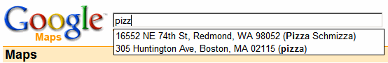
The need for an easier and faster way to search on GMaps has also been discussed on many blogs and one of the suggestions on how to make searching on GMaps easier was to use “aliases”. Searching on GMaps requires a specific and unique business or address and it is not always easy to remember the exact address, however GMaps is very good at recalling addresses. Therefore Google has come up with the idea of using aliases to make it easier for users of GMaps to quickly recall addresses that have already been looked up. When typing in an address for the first time all you have to do is at the end of the address add in a key word or phrase in brackets that relates to the address. Then the next time that you need to find the same address the user just has to type in the key word or phrase and a list of options will appear for the user to choose from. These aliases are able to be managed in the “saved locations” section on GMaps. The majority of the posts that have been posted are from people that like the idea of using “aliases” and think that it is a natural progression to bigger and better things, “This is neat. But Google Maps still needs a quick & easy way to put an ad hoc ~set~ of markers down on a map, say corresponding to a set of saved locations. That way you wouldn't have to make and print a different map for each place or route, but could see them all on one multi-place map. The ability to name and save locations is a good start -- and the multi-place map is a natural next step.” (This was posted by David on May 19, 2007 11:07 PM PDT).

Graphics
The Earth is approximately 40,000 km around the waist. Whoever says it’s a small world is being cute. If you stored only one pixel of color data for every square kilometer of surface, a whole-earth image (flattened out in, say, a mercator projection) would be about 40,000 pixels wide and roughly half as tall. That’s far more than most 3D graphics hardware can handle today. We’re talking about an image of 800 megapixels and 2.4 gigabytes at least.Google Maps deals in resolutions that can resolve objects as small as half a meter or less. We’re talking about images that would (and do) literally take many terabytes to store. There is no way that such a thing could ever be drawn on today’s PCs, especially not in real-time. And yet it happens every time you run Google Earth.

GeoEye-1:
In Sept. 6, 2008 launch of GeoEye-1—the world's highest resolution commercial earth-imaging satellite was launched into space. GeoEye-1 is equipped with the most sophisticated technology ever used in a commercial satellite system. Google which has it's logo on the side of the rocket, has exclusive online mapping of it's data. Google will have access to details of 50cm.
                                           GEOEYE-1 Specifications
                               Spatial Resolution
                               Panchromatic Sensor        0.41 meters x 0.41 meters
                               Multispectral Sensor       1.65 meters x 1.65 meters
                               Spectral Range             450–800 nm
                                                          450–510 nm (blue)
                                                          510–580 nm (green)
                                                          655–690 nm (red)
                                                          780–920 nm (near IR)
                               Swath Width                15.2 km
                               Off-Nadir Imaging          Up to 60 degrees
                               Dynamic Range              11 bits per pixel
                               Mission Life Expected      > 10 years
                               Revisit Time               Less than 3 days
                               Orbital Altitude           681 km
                               Nodal Crossing             10:30 a.m.

Keeping it Updated
Updating Issue
The issues with keeping the website up to date is the maps available, road names and new streets, pictures from the satellite, receiving and load time of the pictures and making it available to all consumers or having them update their knowledge due to the new Version 2 of GMaps. When you have chosen your destination you can select your destination and a picture of it will show from the Google Earth. Google Maps had stated that they tweak their website frequently, sometimes once a week because of many changes is being made. In further research this is explained in greater detail.
Problem and Explanation of Each
In the research that has been conducted we have found that Google Maps has many problems with not only updating but having consumer update their knowledge to learn how to use the changes made on the Google Maps. To help fix part of this problem they have setup a one minute video as soon as the page is downloaded to assist new or existing consumers to how Google Maps works and how you can make it work to its optimum capacity for you. Within Google Maps they have also incorporated options of Google Earth. Since Google Earth was such a hit they had decided to incorporate the imagery into Google Maps by selecting your destination a picture will pop up of that destination. Then problems do stem from there as discussed in “Graphics”. Since they have incorporated this new feature there is more to load onto the site which may slow down the process which is further discussed in “Speed “and “Memory”.
The big issues they have been experiencing are with the new Version 2 of GMaps API. They have designed this website to be 99% backwards compatible with the previous version of API. This new version includes new map class containing updated information. The problem they are having is phasing out the Version 1 of API because Version 2 of API only works with the new GMap interface. Therefore, anyone who is using the Version 1 will not get any of the updates or new map class. There are also other incompatibilities between Version 1 and Version 2 that still need to be “debugged”.
The incompatibilities between Version 1 and 2 include, browser support, Safari is no longer supported, can no longer call setMapType recommended to use setCenter to set zoom and undocumented methods, significant changes to core parts meaning all undocumented functions have changed or are no longer supported. This has been stated as the biggest hassle and most frustrating site upgrades is undocumented functions between Version 1 and 2. Therefore, it is going to be trying for Google Maps and the consumer to upgrade to the new Version 2 GMaps. Google Maps has included whatif cases and how to deal with it as shown in appendix A for Google Map users and also shows the changes made within the core to Version 2 of GMaps.
For the consumer point of views this is what we have gathered for their problems they have been experiencing within the Google Maps website. Adam the editor had written a letter to Google Map users to be aware of their changeover to be identical to Tele Atlas. Therefore will experience some improvements and some problems but encourage visiting the Google Map Discussion to report difficulties. They are trying to be as helpful and understanding as possible by incorporating the video and discussions. They have also incorporated a “feel free to correct it yourself” option on Google Maps which could lead to false information and becoming less reliable. These are some blogs of consumers having problems with Google Maps, complaints about imagery, features missing and update not being made. “Well, no updates to my hometown. Still a green blur. I guess Stone Hedge is more important than the beautiful, bucolic Athens, Ohio? Puhleaze. “(This was posted by Cory, April 24 at 11:35am). “What happened to 3d buildings, I thought at one point Google would allow users to view buildings in a 3d aspect. Otherwise what is the point of tilting up and down?”(This was posted by Eugene, April 24 at 11:45am). “Yeah, I noticed the "update" last week. I used to have great resolution in my neighborhood - Hartford, WI and now it's terrible.” (This was posted by Macewan, April 24 at 12:28pm). These are all blogs to do with different issues that consumers are upset with and they all have to do with the update and the different resolution and features missing.
The largest problem that’s been found with consumers is the updating of information that they have paid for and requested to be but onto Google maps. “I've been reading the Group Discussion for business owner, each day tons of people complain about 3-4 months old listings which have still not been updated. They seem to have some major technical problems. Business owners are almost freakin out there. Listings verified back in July and August has still not been updated.”(SEOPTI at 1:31 am (utc) on Nov. 2). Consumers are starting to fear the Google Maps is no longer reliable because their updates aren’t frequent enough therefore, business owners and your everyday traveler is becoming very upset and depleting the use of Google Maps all together.
Recommendations
The solution that Google Map has come up with is plausible because it lets the consumer know they are trying to debug the system but then again it’s very frustrating to the consumer not having these problems fixed. Therefore, deterring their confidence in the technology and will use another source for their information. Having incorporated the video as soon as the website downloads was a great idea because it gives the consumer a chance to learn what’s new and what features are available to them with the new Version 2 GMaps. We suggest they keep the Version 1 GMaps available for longer because the consumer needs time to learn the new system, meaning the new features available.
Appendix A
Type Version 1, Version 2
constructor GMap (container, mapTypes?, width?, height?,GMap2(container, opts?)
method GMap.getCenterLatL(),GMap2.getCenter()
method GMap.getBoundsLatLng(),GMap2.getBounds()
method GMap.getSpanLatLng(),GMap2.getBounds()
method GMap.getZoomLevel(),GMap2.getZoom()
method GMap.centerAtLatLng(center),GMap2.setCenter(center, zoom?, type?)
method GMap.recenterOrPanToLatLng(center),GMap2.panTo(center)
method GMap.zoomTo(level),GMap2.setZoom(level)
method GMap.openInfoWindow(point, node, offset?, onopen?, onclose?(),GMap2.openInfoWindow(point, node, opts?)
method GMap.openInfoWindowHtml(point, html, offset?, onopen?, onclose?,GMap2.openInfoWindowHtml(point, html, opts?)
method GMap.showMapBlowup(point, node, offset?, onopen?, onclose?),GMap2.showMapBlowup(point, opts?)
event GMap.click(overlay, point),GMap2.click(overlay, point)
event GMap.zoom(oldLevel, newLevel),GMap2.zoomend(oldLevel, newLevel)
constructor GMarker(point, icon?),GMarker(point, icon?, inert?)
method GMarker.openInfoWindow(content),GMarker.openInfoWindow(content, opts?)
method GMarker.openInfoWindowHtml(content),GMarker.openInfoWindowHtml(content, opts?)
method GMarker.openInfoWindowXslt(xml, xslt)
method GMarker.showMapBlowup(zoom?, type?,GMarker.showMapBlowup(opts?)
constructor GPolyline(points, color?, weight?, opacity?),GPolyline(points, color?, weight?, opacity?)
constructor GIcon(copy?),GIcon(copy?, image?)
constructor GBounds(minx, miny, maxx, maxy),GBounds(points)
constant G_MAP_TYPE,G_NORMAL_MAP
constant G_SATELLITE_TYPE,G_SATELLITE_MAP
constant G_HYBRID_TYPE,G_HYBRID_MAP
static method GXml.parse(xmltext),GXml.parse(xmltext)
method GXslt.transformToHtml(xmlnode, htmlnode).GXslt.transformToHtml(xmlnode, htmlnode)
Conclusion:
Memory
Memory has two types of nodes:
A large number of chunk servers, which are cheap "commodity" computers used to store information in 64 megabyte chunks;a nd a master server which doesn't store the actuall chunks, but all the data associated with the chunks such as the location of the chunks and the actions being taken toward the chunks.
Graphics
Google Maps works with 800 megapixels and 2.4 gigabytes of mapping information. Google maps deals in resolutions that can resolve objects as small as half a meter or less. Google's images are supplied by the satellite GepEye-1 the world's highest resolution commercial earth-imaging satellite.
Speed
Revisions to google maps API version 2 found that if by shrinking google maps JavaScript homepage from 100k to around 70k or 80k that the overall speed of google maps was increased. Once this "shrinking" occurred the overall traffic on google maps was up around 10% within the first week, and around 25% shortly after. With this improvement in the speed of google maps API blog states that now google maps can remove 100 markers in 1.5 seconds instead of 18 seconds in Internet Explorer, and it takes 0.5 seconds instead of 8 seconds in Firefox.
Keeping It Updated
The issue with keeping google maps updated is that if it is not updated in time users will recieve inaccurate directions. This has resulted in many complaints from users, and users have said that they can no longer rely/depend on google maps for directions. The users unsatisfaction with the website may change their mind about using this feature of google and moving onto other map providers such as Yahoo Maps.
References
2)http://code.google.com/apis/maps/documentation/upgrade.html#UpgradeOverview, Cnn.com
3)code.google.com/apis/maps/documentation, Google Code
4)http://groups.google.com/group/google-maps-current-issues/browse_thread/thread/76d642a516a7a754, map guide Adam
5)http://www.gearthblog.com/blog/archives/2006/04/google_maps_and.html, Google Earth Blog, Posted by: Cory at April 24, 2006 11:35 AM
6)http://www.gearthblog.com/blog/mt- search.cgi?IncludeBlogs=1&search=buildings, Posted by: Eugene fat April 24, 2006 11:46 AM
7)http://www.webmasterworld.com/local_search/3494231.htm, Google Maps – Major Updating Problems
8)http://www.boingboing.net/2005/02/09/how-google-maps-work.html
9)http://www.realityprime.com/articles/how-google-earth-really-works
10)http://www.jonlee.ca/how-does-google-store-all-of-its-data/
11)http://communication.howstuffworks.com/google-file-system.htm
12)http://www.slideshare.net/tutchiio/gfs-google-file-system/v1
13)http://www.geoeye.com/CorpSite/products/imagery-sources/Default.aspx
14)http://en.wikipedia.org/wiki/GeoEye-1
15)http://www.worldmapsonline.com/SatPosters/FourViewsEarth.htm
16)http://blog.wired.com/gadgets/2008/08/google-launches.html
17)http://mediakey.dk/~cc/speed-up-google-maps-based-applications-with-caching/, Mediakey
18) http://groups.google.com/group/Google-Maps-API/browse_thread/thread/7984397c9bf0a020/949bf2db5208671e?lnk=gst&q=clustering#, Google Groups
19)http://www.robrich.org/archive/2008/11/08/oh-duh-google-maps-and-iphone.aspx, Rob’s Blog
20)http://googlemapsapi.blogspot.com/2006/07/speed-improvements-custom-cursors.html, Blog Spot
21)http://blogs.zdnet.com/BTL/?p=3925, zdnet
22)http://lifehacker.com/software/google-maps/speed-up-address-lookups-with-aliases-262235.php, lifehacker
23)http://forum.heliocity.net/index.php?topic=7578.0, Heliocity
24)http://geography.about.com/od/streetroadcitymaps/gr/googlemaps.htm, About.com
25) http://dailydiy.com/2007/05/21/google-maps-speed-up-address-lookups-with-aliases/, DailyDIY
26)http://en.wikipedia.org/wiki/Google_maps, Wikipedia
27)http://googlesystem.blogspot.com/2007/05/google-maps-aliases.html, Google Operating System